Researching Crime
CrimeMalta Observatory is a publication aimed at depicting the Maltese safety and security landscape in visual form.
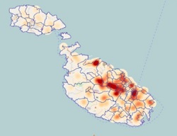
The CrimeMalta Website brings you real crime analysis based on 27 years of research. In a study initiated in 1997, crimes from 1950 to date have been geocoded and digitised to help create analytical tables and charts that are easy to understand and review. Using state-of-the-art technology (GIS - Geographical or Spatial Information Systems), crime reported to the Malta Police Force since 1998 have been mapped based on the offence location.
This process enables spatio-temporal analysis of crimes in Malta by the location they occur in, when they are committed and the potential link to the place they occur in. A Web-GIS of Maltese Crime enables users to browse and print maps of crime at different spatial layers such as districts and local councils as based on the NUTS (administrative units classification) nomenclature. Smaller units have been analysed foremost amongst which are enumeration areas as identified by Census.
.